Showing posts with label tramping. Show all posts

Friday, July 18, 2014

Dragonflies and TedX

What do these two have in common? Not a whole lot really but Dragonfly Peak can be found in the Mt Aspiring National Park (close to Wanaka) and Wanaka also just hosted their very first TedX event. As a fan of Ted talks (TED.com) I had a look around at Ted events that I might be able to attend. First up for consideration was the Ted Global conference to be held in Brazil next year. Sadly the conference ticket price was USD$6,000 – with flights, accommodation and meals to add to the cost that was definitely out of reach. A colleague happened to mention a TedX event coming up in Wanaka and the ideas started to grow. Wanaka? Hmmmm, close to loads of climbing opportunities.

Before long a plan was hatched, a couple of days annual leave booked, climbing gear packed and we were off to Wanaka via Dunedin. We arrived late at night in Wanaka for a sleep and repack before heading off to 
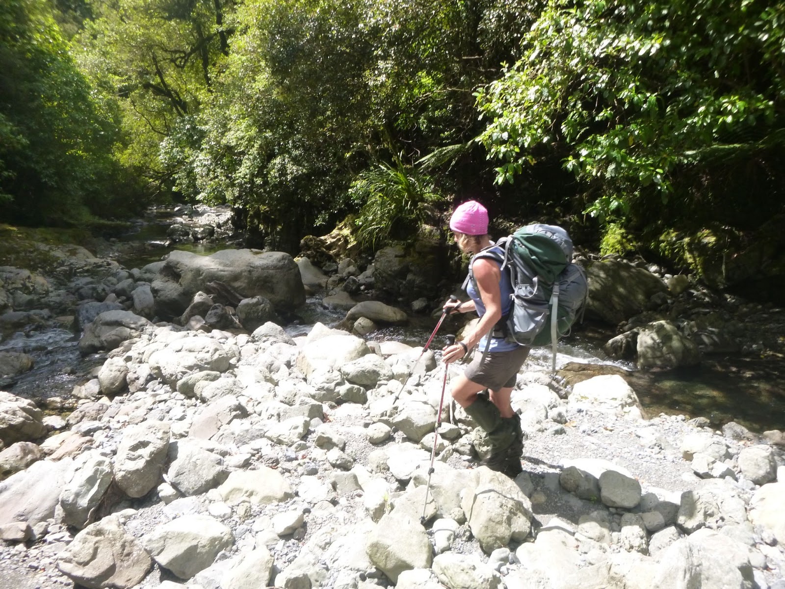
the East Matukituki valley on the Thursday morning. Lugging our 20kg packs (ugh) we crossed the (cold) river and set off up the valley with the intention of climbing to below the Albert Burn saddle before setting up camp for the night. 
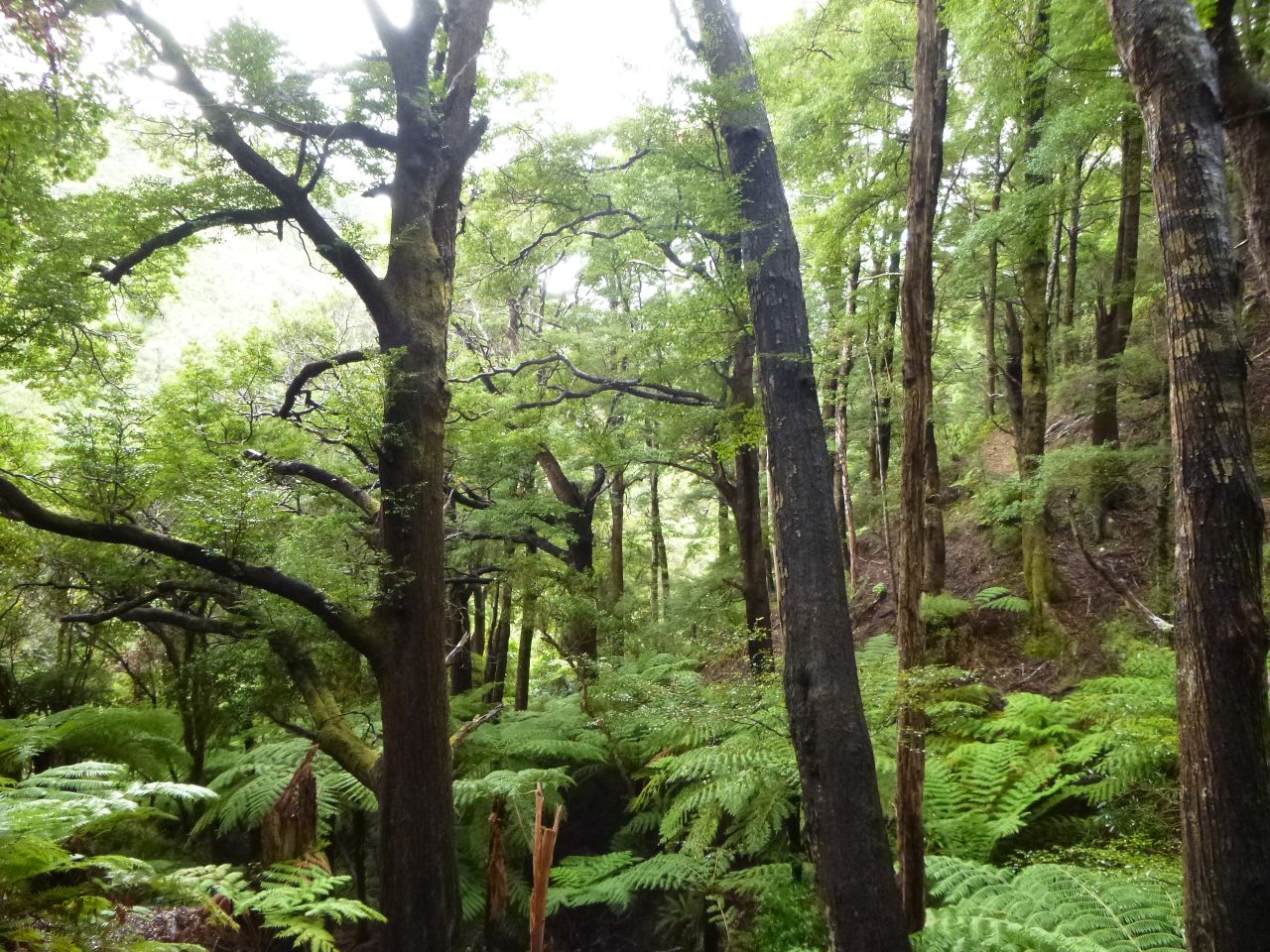
That day saw us crossing farmland, wandering through bush and over streams then climbing up through bush and tussock for around 1000m before finding a relatively flat spot by a partially frozen tarn to set up camp for the night as the sun went down. I can safely say it was freezing that night. The ground was quite frozen and there were a few patches of snow around. Luckily we had our alpine sleeping bags and slept in most of our clothes so had a snug night before an early start the next morning. While getting our gear sorted I realised how cold it had been – water stored inside the tent had frozen as had my sunscreen.


Campsite on the first night

A cup of tea and bowl of porridge was appreciated before climbing up to the saddle and the Whare Kea chalet. We positioned ourselves in front of the chalet’s webcam while getting geared up for the climb up to Dragonfly Peak.

 
When we got back to civilisation we found there were two images of us online from the chalet’s webcam – mission accomplished!

 Whare Kea webcam photo – Mt Aspiring in the background

View of Mt Aspiring from Dragonfly Peak

The climb to the peak was relatively straight forward. We had a couple of stops along the way to take photos including some pictures of a couple of chamois who casually wandered past us. At one stage my climbing partner headed off to clamber over some rocky bits while I found a different route up a snow slope. I thought I had found the easier route until halfway up when I realised the snow quality wasn’t the best and it was a lot steeper than I had first thought. At that stage it seemed a good idea to carry on instead of retreating which I did. We regrouped on the summit and had a break there, taking photos and enjoying the view.

Heading towards the summit of Dragonfly Peak
On the way back down we made the decision to descend down the route that I had climbed. Interestingly it was decreed that the route was much harder and riskier than the rock route. Oops. Anyway, no falls occurred and we continued back down to the chalet for a leisurely lunch on the deck. After an enjoyable lunch in the sun it was time to descend back down to the valley floor to find a campsite for the night.

Descent down the tricky bit

After starting our climbing at 9am we found somewhere to camp at about 6:30pm in amongst the trees. That night there was a rather exciting electrical storm somewhere straight over the top of us – lightning flashes and thunder were happening almost instantaneously. Early the next morning it was time for a quick packup (no time for breakfast) before heading off to get back across the river to the car and back into Wanaka. With no place to shower we got to a café in Wanaka for a late breakfast and changed into more acceptable attire before heading out to Rippon Hall for the start of the TedX event.

TedX


TEDx was created in the spirit of TED's mission, "ideas worth spreading." It supports independent organizers who want to create a TED-like event in their own community.

 The Wanaka event was the 7th TedX held in New Zealand and possibly the smallest with a limit of 100 tickets. Participants were encouraged to meet up with others so we were asked to add something about our interests onto our nametags. That provided a good conversation starter and people mingled well.
 
The day was split into three sessions with breaks in between for conversation and snacks / drinks. The seven speakers were all NZ based and were a diverse bunch – author Derek Grzelewski, retired psychiatrist Ken Bragan, nanotechnologist Michelle Dickinson, blogger Liz Carlson, leadership expert Andrea Thompson, fridge hitchhiker and author Rob Cope and ecologist Steve Sawyer.

After watching a lot of Ted talks online over the past few years I wondered how a NZ event would compare. Certainly the speakers were not as polished but their talks were all compelling to listen to and the audience were certainly engaged, amused and interested through all of the presentations. In addition there were a couple of other Ted videos played – one of which I’d seen before but the other one was of particular interest to me. I’ve been working on a bit of a proposal around a Wellness programme for Redvespa and the content of the talk (http://www.ted.com/talks/shawn_achor_the_happy_secret_to_better_work) has led me to pause and think about the content of my proposal. The talks from the Wanaka event will be available in the near future on Youtube.

The only downside to the event was the constant thanks to sponsors that was required between every talk / video / performance. That was pretty tiresome as the day wore on. Apart from that, the entire day – the venue, the talks, the entertainment, the food and the people – gave me a real buzz.

Overall I’d recommend attendance at these types of events as well as watching Ted talks online – they certainly provide a wealth of information and a hefty measure of inspiration. There are TedX events scheduled in Auckland (16 August), Tauranga (14 July) and Christchurch (1 November) and I’ve also heard that there will be an event in Wellington too although this has not yet been scheduled. If you’re able to get a ticket, get along to one of these events for an inspirational time. Tickets for Wanaka were just over $100. Totally worth it for the talks as well as the food and drinks provided.

Wednesday, October 30, 2013

News flash - I won a scholarship

My big news is that I have been successful in attaining a part scholarship to attend a High Alpine Skills Course in the Mt Cook area in January. The scholarship was offered by the NZ Alpine Club and sponsored by the Wellington and Auckland Women Climbing groups. The course is a fantastic opportunity to learn some new skills (of specific interest to me, they cover off glacier travel and crevasse rescue as part of the course) that will be of tremendous benefit to my own personal climbing as well as adding to my skillset for teaching other people. I'm particularly interested in encouraging other women to either take up climbing or take the next step in their climbing. With my memberships to Mountain Safety Council and the Wellington section of the NZ Alpine Club I'm in a great position to enable this.

I've been catching up on some reading recently (prior to knowing about the scholarship) and have just finished reading a book about Bill Denz and also one written by Karen Gazley - both climbers. Both books were a great read. I found both books, to some extent, inspiring but not to the point where I would want to emulate Bill Denz. I think my personal approach to risk is somewhat different to what Bill's was.

With the course lined up for mid-January, my summer is shaping up to be a great one. Hopefully I'll get some climbing in before the course at the Alpine Club annual climbing camp which is taking place in the Hopkins Valley. Prior to Christmas some forays up into the hills for some tramping will be the plan - time to get lean and mean, ready for climbing.

Wednesday, October 9, 2013

Four in a row - tramping fun!

Recently I learned I would be physically out of action for a period of time - this was a blow as I had plans to be climbing Mt Aspiring in November and this plan would now need to be shelved. As might be expected of me, my reaction to an enforced period of inactivity was to ramp up my weekends for the remaining period with some tramping trips.

As with all our trips we had several backup plans in place in case the weather didn't play ball. Plan A for the first trip was to head up to Mitre Peak in the Tararua range for a spot of snowshoeing to take advantage of a recent southerly blast. This would have been a strenuous but fun trip. Sadly the weather gods threw a curve ball with rain and gales on the tops so the trip ended up being an easy wander in to Mitre Flats hut for the night and back out the next day. The positive for the trip was having the hut to ourselves - the previous two occasions I've been in that hut have seen an overflow situation with people sleeping on the deck and camping outside.

Waitewaewae slip
Trip 2 went according to plan with a pretty average weather forecast being wrong and being delivered two lovely sunny days. The plan was a walk in from Otaki Forks to Waitewaewae Hut (also known as YTYY or Y2YY) on the banks of the Otaki River. There had been recent activity on the long standing slip which made for an interesting few moments of near-terror as we scrambled across that. The decision was made towards the end of the tramp in to take the dry weather (wet feet) track to the hut. With scant information we headed off for that and took a bit of time to figure out that meant a walk across then up then across the river. The final river crossing was chest height in frigid water - luckily the hut is right by the bank of the river so dry clothes were soon available and the fire was kicked into action to warm us up. Again we had the hut to ourselves for the night. The walk out the next day was uneventful although the decision was made to take the wet weather (dry feet) track back out to avoid a morning dip.
Otaki River - looking benign.... and cold

Trip 3 was a less than perfect weekend with low cloud and rain. Nevertheless we headed off for a short walk up to Kapakapanui Hut at the back of the Reikorangi Valley behind Waikanae. For the third week in a row we had a hut to ourselves so settled in for a quiet afternoon of reading before dinner and bed. Listening to the rain through the night we wondered how the river crossings would be on our way back out to the cat the next morning. After breakfast and packing up we headed off to walk up over the summit before dropping steeply down to the carpark. The river was a little higher than the day before but still crossable. Lucky. Would have meant a long walk otherwise.
Kapakapanui Hut

Wangapeka slip


Finally we were down to my last weekend and we were lucky enough to be in the South Island. Yet another soggy forecast meant a change of plans and then a road closed due to a slip caused another change of plans. Off we headed, on the Wangapeka Track to Kings Creek Hut for a couple of nights. As with the Waitewaewae track, there was an active slip on this track. And, wow, what a slip!

There are warning signs at the beginning of the track and on both sides of the slip advising that the slip should be crossed quickly, that spotters should be used for falling rocks etc. The slip happened in October 2012 and has partially blocked the river resulting in quite a lake behind it complete with trees that are dying (slowly drowning I guess).

We got through to the hut ok and then it started raining and didn't stop. When we first arrived there we had a dip in the river. By the next morning the river was heavily flooded.

Kings Creek Hut
Five minutes further along the track is Cecil King's old hut. Cecil was a miner who spent a lot of time in the area and his old hut has been restored and has 4 bunks available for people to stay there. It's a cool little hut with an open fire and easy access down to the river.

Cecil King Hut
After a couple of nights at Kings Creek hut it was time to head for home. Despite the continual rain the slip was passable. The next hurdle was a ford we'd driven through on our way to the track - it was dry when we'd driven through it on the way in. After all that rain it was flowing pretty high - lucky we had a rental car. The rain had eased off and you could see that the river level had dropped significantly. Lucky - we would have been pretty stuck otherwise. It's one of the few fords I've seen that has a footbridge alongside to allow people to exit (without their vehicle of course) when the river is high.

So, four tramping trips over four weekends. In all cases we had the huts to ourselves and only saw other people on the Waitewaewae trip. Luxury!

Now it's time to rest up and recuperate in time for some summer trips.

Tuesday, May 14, 2013

Autumn weekend in Wellington

With the forecast looking grim and a birthday to celebrate we had a think about a place to eat out on a miserable Wellington Friday night. After pondering for a while we decided our money would be better spent buying some seafood, grabbing a bottle of wine and heading to the Rimutaka Forest Park to camp for the night. With the wind blowing a gale and showers passing through we cooked our feast of scallops, blue cod, prawns and squid and supped on red wine and a wee whiskey before slipping into our sleeping bags.

The following day we were off to do some tramping and then to camp for a second night. After managing to pack up without getting wet we headed off for a day of tramping. The weather wasn't great - pretty wet but not too cold. The foliage looked much greener with a bit of rain on it.


The following morning dawned calm and sunny - just in time for Mother's Day. No breakfast in bed for me! After packing up our campsite it was a short walk back to the carpark. After a bit of discussion about what I'd like to do for Mother's Day we ended up at Petone Beach with some lovely grilled fish and chips in the sun for lunch. 

A perfect weekend!


Tuesday, April 2, 2013

Back on the saddle again

After a frustrating 8 weeks of no activity I've been given the all clear to "resume normal activity" by my specialist. He has advised me that, while I may experience ongoing pain (for up to 6 months) healing will continue and I can't do any further damage to my sacrum (unless I fall on it again I guess). I was thrilled with that and checked with him that I could get back on my bike. There was a little intake of breath at that question so I was told to go for a short ride and see how it felt.

A few days later I hopped on my bike, rode round the block and then rode to Upper Hutt and back - a distance of about 40-odd kms round trip. While I certainly experienced some tenderness and stabs of pain it was bearable. I took that as being successful and have gone back to commuting to work and back each day. The worst pain is when I get out of the saddle for steep hill climbs so that's a little limiting. The vast reduction in my fitness level (and the subsequent increase in weight) has been extremely frustrating and every day has been hard work - especially with the fresh / gusty northerlies we've been getting here in Wellington.

Over Easter was the next test - a shortish tramping trip with a pack on my back. My son's girlfriend and I headed for the hills for a 4 hour tramp to a hut for an overnight stay then return. Again, the pain was certainly there but bearable. A few pretty awful twinges but nothing long lasting.

This weekend coming is the Oxfam Trailwalker event (a walk of 100kms). I withdrew from this event and the weekend of tramping has confirmed that this was the right decision. While I can handle the pain for short periods of time, a 24-hour+ walk is out of the question for me. I will be there as support crew but that is as far as my contribution goes unfortunately. I'll be there to cook, massage and encourage as needed. Maybe next year I can be in the team.

Monday, March 11, 2013

A trip to Arete and back

A great weather forecast at the beginning of February led to an overnight trip into the Tararua range with the goal to walk in to Arete Bivvy. The track starts out the back of Levin and we headed off up the Gable End track towards the tops. After walking for an hour or so I was feeling unwell and lacking in energy so we decided to carry on to Te Matawai hut and figure out what to do from there.

Gorgeous day for a walk

On the way to Te Matawai Hut

Te Matawai Hut
After a less than enjoyable trudge up to the hut the decision was made to have dinner and stay at the hut for the night. In the morning we would leave our packs at the hut, head up and over to Arete Bivvy before walking back out to the car via the South Ohau Stream. There were a few other people in the hut but after dinner it was time for an early night and a good sleep. The morning dawned fine with a little bit of cloud on the tops. While getting pack up ready to go I somehow managed to fall from the bunk steps onto the wooden floor. Luckily I have enough padding on my butt so the fall didn't cause any damage. We got ourselves packed up, sorted out gear and food for the walk up to Arete and headed off. While I felt a little better than the day before I was still not 100% so was walking slower than my normal pace. It was great to get up onto the tops and it didn't take us long to get to the high point of Arete and then descend down the other side to the bivvy.
On the way to Arete Bivvy

View along the tops

Arete Bivvy - cute little hut

Looking back down to Arete Bivvy - Wairarapa in the distance
The bivvy itself is a cute 2 person hut nestled in grass and tussock with one of those amazing loos with a view. After a rest break and a water topup it was time to get ourselves back to the hut to pick up our packs and start the descent down to the South Ohau Hut then down the stream to the car. I enjoyed the descent a lot more than I had enjoyed the climb so we made pretty good time going down. The descent down to South Ohau Hut is pretty steep and rugged. The hut itself is beside the stream and looks like a great place to stay. We decided we'd have to come back another time and spend a night there.

South Ohau Hut

View from in front of South Ohau Hut
We had a snack and a brief rest stop before entering the stream for the walk back to the car. Unfortunately, we had only walked for about 10 minutes when I slipped on a rock and landed heavily on my butt. It was one of those awful moments when you realise you've done some real damage and that the rest of the day would be a little different than planned. After dumping my pack off my back and gingerly getting to my feet (I was dry I might add - somehow I landed right on the flat, dry rock that I had slipped off) I knew that I had managed to damage something pretty badly but that I could still walk. After swapping some gear out of my pack to lighten the load we set off down the river towards the car. Pretty much every step was agony with any climbing over rocks intensifying the pain. I did wonder if I had lost enamel from my teeth from all the teeth-gritting that was going on. It was definitely no fun and there was little to no conversation going on during the walk out. It took about 4 hours to walk out to the carpark where we then had the drive home to cope with.

South Ohau Stream

South Ohau Stream


South Ohau Stream
A trip to the doctor the following morning and an xray a couple of days later revealed a displaced fracture of the sacrum. On looking that up on Dr Google it looked like a scary proposition but it seems that it all depends where the break is as to how serious the fracture is. Mine is right at the bottom of the sacrum - just above the coccyx - which is, apparently, far less serious than breaks higher up. It still means a healing time of 6-12 weeks, up to 3 months off my bike and all other physical pursuits are on hold for now. This makes for a very bored Carolyn with the prospect of not being able to get out and about for a while.

Tuesday, March 5, 2013

Hillary Trail - Wellington Anniversary Weekend

The opportunity arose to be in Auckland over Wellington Anniversary Weekend this year so I scouted around to see what we could do with that time. I stumbled across the Hillary Trail which is a 70km, 3-night walk from the Arataki Visitor Centre to Murawai.We only had three days (2 nights) available so arranged to leave the trail early at Piha Beach. Information on the trail was readily available on the internet but warned that the walk was a hard, long walk.

Day 1 - Arataki Visitor Centre to Whatipu

We fronted up to the Visitor Centre at about 11am on the Saturday morning and set off to Karamaratura (just past Huia) which was a 10km walk.


This part of the trail had warnings about the boggy nature of the track and was expected to take 4-5 hours to get to the campground. The track itself was fine. Slightly boggy in places but certainly better than some areas of the Tararuas as far as mud went. After an enjoyable walk we arrived at the campsite at 2pm - it only took us 3 hours to get there. We stopped at the campground for lunch and then figured we may as well keep walking for a few more hours (another 10kms) and head to Whatipu for our first night.

Part of the track between Karamaratura and Whatipu

Trying to get phone reception on the hill above Whatipu (a little windy up there)
Picture looking towards Whatipu and the entrance to Manukau Harbour
We arrived at Whatipu late afternoon and set up camp at Cave campsite. This was a very small camp ground that provided a small number of tentsites and a toilet. There was fresh water available about 15 minutes walk away at the main Whatipu campsite. There were a number of people already at Cave campsite when we got there so it was a little tricky finding some flat ground to set up camp for the night.

Just enough room for a small tent at Cave campsite
We got that sorted and then had dinner just before the sun went down. A very enjoyable first day on the Hillary Trail.
 
Sun setting at Cave campsite

Day 2 - Whatipu to Craw campground

 Day 2 dawned a little wet and miserable so we packed up our tent and headed into one of the caves nearby to have breakfast.
Breakfast spot in the cave
From here our destination was Craw campground just north of Piha, a walk of 21.5kms. Today would be a mix of walking in the bush and then on the beach to Karakare before enjoying a with a little bit of civilisation at Piha. Luckily the weather cleared up and the day turned out warm and sunny. After a little while we reached Pararaha campground which is where we had intended to camp on our second night. Clearly we were walking the trail a little quicker than the signposted times. We managed to get within cell range to change our plans of leaving the trail early and sort out a pickup from Murawai instead of Piha. Along the way we walked through the Tunnel Grove campground. This was an awesome spot and, if we'd known about it, we would have arranged our walk to stay there.
Tunnel Grove campground
The tunnel by the campsite complete with the abandoned boiler which didn't fit through the tunnel


From that campsite the walk continued along the beach all the way to Karekare. Rather hard work walking in sand with a pack on. At Karekare we climbed a small hill to where the Hillary Trail continued and sat and had lunch in the sun.

Beach at Karekare
View from our lunch spot at Karekare
After lunch at Karekare we headed back into the hills and came across Mercer Bay. We noticed a group of guys ziplining across the top of this bay so we stopped to watch them for a while.

Mercer Bay
From Mercer Bay we carried on towards Piha where the trail winds its way past the Kitekite Falls.This was a popular spot for families swimming.
      
Kitekite Falls at Piha
After a brief photo stop we headed into Piha where we had a well-deserved icy cold cider before carrying on to Craw campground.
Beach at Piha - Lion Rock in the middle of the photo
Campsite at Craw campground
There were a couple of guys camped here who were also doing the Hillary Trail. They had decided to exit early though and not do the final day through to Murawai. We had a pleasant night here with an early start the next morning. The information on the trail said that the walk from Craw to Murawai would take 11-12 hours. With a 5:30pm pickup from Murawai organised we figured we should get an early start so headed off at about 7am.

Day 3 - Craw campground to Murawai

From the campground we headed over farmland for a while before the trail went back into the bush heading away from the coast for a while. After a long descent we walked alongside Lake Waimanu and then some huge sand dunes to Bethells Beach (Te Henga).

Lake Wainamu
At Bethells Beach we continued on the trail but had a great view down to the beach where some filming was taking place. Not sure what the film is but there were horses and what looked like Roman soldiers involved.


Bethells Beach - Te  Henga
After a short climb over the hill by Bethells Beach we stopped for a swim at O'Neills beach. The sea looked a little treacherous here but it was great to have a dip and wash off some of the accumulated sweat and dirt from the previous two days.
Te Henga Walkway - O'Neill Bay
After our refreshing swim we carried on. We were now on the Te Henga walkway to Murawai.
Te Henga Walkway - from Bethells Beach to Murawai
Somewhere towards the end of the walkway we stopped on the side of the track for a lunch break. We were making good time so were confident we would easily get to Murawai in time for our pickup at 5:30pm. After lunch we carried on to the end of the Te Henga trail - the last part of the trail to the road into Murawai climbs a series of wooden steps. Not the sight you want to see after having walked a decent distance already. Once we finished climbing the steps we were onto a mix of road walking (boring and hard on the legs) and trails through the bush. This took us through to the gannet colony and then onto the beach at Murawai. We celebrated our arrival with a swim in the surf there. It felt great! Once we were suitably refreshed we made our way to a cafe for a cold drink while we waited for our ride. All up the day had taken us about 9 hours - including stopping for a swim and a relaxed lunch break as well as numerous photo stops along the way.

Small part of the gannet colony at Murawai

Summary

We enjoyed our three days walking the Hillary Trail. From our perspective, the numerous warnings about how rough, tough and long it was were overstated. The track was pretty dry when we walked it so I can imagine after (or during) rain progress could be a little slower. There are certainly improvements that could be made to the trail and the literature. Signage was either over the top with Hillary Trail markers very close together to non-existent where no Hillary Trail markers could be seen and no other useful signage to indicate the start of tracks. Carrying the detailed brochure as well as a detailed map for the area assisted us in a few places where the route was unclear. The estimated times were overstated for the pace we were walking. Given that we were carrying reasonably heavy packs with camping and cooking gear, etc I don't think we were walking particularly fast.The maps for the trail show the route between Pararaha to Karekare is in the hills but the markers have that section walking along the beach. There was no information provided on that change and no mention of it at the visitor centre at the beginning of the trail. It would be good to have more information in the brochure about some of the other campsites and maybe a breakdown of the times between different sections of the walk. And my last point was to not take much notice of the profile map in brochure. The profile for the whole 70kms is printed across the page resulting in an unhelpful profile that doesn't show any details. It would be much better for the profile to be split for each section of the trail and to be printed in landscape.

Thursday, January 24, 2013

Christmas Holiday 2012 - final instalment

After our previous adventures in the Mt Aspiring area we found that the weather forecast looking forward was pretty rubbish. We had organised a cheapo flight from Makarora into Siberia with the view to doing some climbing in the area. With heavy rain forecast that idea went out the window and we headed to the DOC office to figure out our alternatives. It seemed that most of the South Island was about to be drenched so we made the call to head to where the rain would potentially be the worst - Fiordland! What the heck?!?!

We spent a soggy night camping at Makarora.


In the morning we packed up a damp tent and started the drive from their, past Wanaka and Queenstown to a lodge down by Lake Monowai (south of Manapouri. Once there we checked in with the manager of the Borland Lodge who informed us that the topo map for the area was incorrect and that a bridge marked on the map didn't exist. With the forecast rain we realised we would be able to make it through to North Borland Hut but that we would have to wait for the river flow to reduce before we'd be able to make it back out again. So we packed up plenty of food and headed up the North Borland track. As it was late in the afternoon we stopped for the night at a rock bivvy. The bivvy had a wooden platform for sleeping on. Due to the large number of sandflies we pitched the inner of our tent on the platform.

Rock bivvy
The following morning we carried on along the track to North Borland Hut. On the way we crossed the mid branch of the Borland River and took note of the waterflow. This was the river that didn't have a bridge on it and the river catchment area was huge so would definitely flood.
Mid branch of the Borland River looking very serene

Typical bush - loads of moss due to the general wetness


After a few hours we reached the North Borland Hut which would be our home for the next few days. The hut is a 2-man basic DOC hut. There's an open fire, a bunk, a kitchen bench, a wooden bench for sitting on and a long drop out the back towards the trees. Unfortunately the roof leaked so the top bunk was out of commission during our stay. Two of us scrunched into the bottom bunk made for some cosy nights.
North Borland Hut
Inside North Borland Hut
   
Borland River - before the rain


View from the side of the hut looking across the river (now in flood)
During the night we got to the hut it rained. A lot. On checking the situation through the night we realised that surface flooding had resulted in the hut being completely surrounded with water - close to knee deep in places. We made sure to lift all our gear off the floor during the night just in case the water came through the floor. Due to pretty much constant rain, the next day was spent lounging around in the hut. We read and did Sudoku puzzles for the day. It was still raining on the following day but we decided to head off for a walk further up the valley anyway. We stuck to the true right of the river heading up the valley which made for some interesting bush bashing at times. Further up the valley we managed to cross the river so returned to the hut on the other side of the river. On the way we found a established campsite including a grave (maybe a mock one?) pictured below. The grave was complete with the toes of a pair boots protruding through the soil.

Grave at campsite
We walked back to the hut and managed a safe crossing of the river. After a good hunt around for firewood we settled in for the rest of the evening and night. We'd been back for a short period of time when we noticed that all the hills around us had a good layer of fresh snow. That would explain why it was a little chilly. Luckily we had done a good job collecting firewood.

Snow on the hills opposite the hut

The following morning dawned quite a lot brighter and we had hopes of getting in some climbing. Unfortunately there were still showers coming through and we had no up to date weather forecast so made the sensible, although frustrating, decision to head back out to Borland Lodge.

View from a high point on the track

Lunch spot on the way back to Borland Lodge
When we got out to the lodge we arranged to stay in one of their chalets for the night. When it came to dinner time we decided to head up to Manapouri for a meal. The options were pretty limited but we had ourselves a tasty meal of flounder and salad before heading back to the lodge.

The following morning saw us heading north towards Queenstown. We figured we had time for one last adventure so drove up to the Remarkables Ski field, packed our gear up and got walking. The plan was to walk up the ski field, climb over the saddle to the other side of the range and bivvy for the night by the tarns at the top of the Wye valley.

View from the carpark looking up the skifield


On top of the saddle

View from the saddle looking down to the tarns
View from close to our bivvy site looking down the Wye valley
It was extremely windy and cold so we built a rock bivvy to give us some shelter from the wind.

  
Our DIY rock bivvy
During the night the wind eased and the sky clearer. The clear sky was amazing with the stars looking very close. In the morning we packed up and headed back down to the skifield carpark before getting on the road to Christchurch where we would catch our flight home to Wellington. After three weeks of tramping, climbing and camping we were just getting in the groove so it was a bit sad for the adventures to be over.

Lake Pukaki

Lake Pukaki with Mt Cook in the background

Campsite close to Christchurch for our last night